
The City of Santa Fe is moving forward with an expanded hydrological study and ecological monitoring plan for Two Mile Pond and the surrounding ecosystem. The data will be used to evaluate water flows to and from the pond, track water losses, and track changes in the area’s ecology over time, to provide the community with accurate information about the region and inform decisions about next steps.
The City will provide updates as the studies progress and has put together the following FAQ for those seeking additional information.
There are two public meetings on the topic scheduled for those who have additional questions about the project and its current status. Due to limited space in the meeting rooms, please click the links below to RSVP for the meetings!
| Meeting Date | Location | Time | RSVP |
|---|---|---|---|
| Thursday, November 30 |
Southside Santa Fe Public Library |
6 to 7:30 p.m. | Click here to RSVP |
| Tuesday, December 5 |
Transit Administration Office |
3 to 4:30 p.m. | Click here to RSVP |
Each meeting will have the same information and format: a presentation by staff on the topic and current updates on next steps, followed by a Q&A. Attendees will have two minutes per question and will be limited to one question each until all present have had the opportunity to speak at least once.
Two Mile Pond FAQ
What is Two Mile Pond and how was it formed?
Two Mile Pond is a body of water near the intersection of Cerro Gordo and Upper Canyon Road that is what remains of a larger reservoir formed by Two Mile Dam. The dam was removed in 1994 due to safety concerns, and the smaller body of water forming the pond was preserved.
Every year since 2009, up to 1,000 acre-feet of water from the Santa Fe watershed has been allowed to flow past McClure and Nichols Reservoirs into the Santa Fe River. This "Living River Water" (Target Flow Ordinance 2012-10) is intended to benefit both the ecosystem and community throughout the City of Santa Fe. Some of this Living River water has been diverted from the Santa Fe River to maintain flow through Two Mile Pond.
Why did the water levels in the pond go down this year?
In 2018, the Office of the State Engineer (OSE) ordered that surface water diversions into Two Mile Pond cease. In spring 2023, a diversion structure that allowed water to be diverted into the pond was removed. In response to concerns about stagnation, City staff also cleaned the outflow pipe from Two Mile Pond in summer 2023, which lowered the water level in the pond to the design level established in 1994.
Without diversions, will the pond dry up and wetlands disappear?
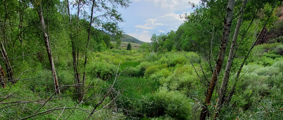
The riparian area from the base of Old Stone Dam (see map later in FAQ) to the outflow from Two Mile Pond is the low point in the area and is fed with groundwater flows from seepage out of the river and regional groundwater. Water has continued to flow through Two Mile Pond throughout 2023 and City staff have never seen flows through Two Mile Pond cease entirely. This wetland area is estimated to currently be over 5 acres in size and is expected to remain a wetland with or without diversions from the Santa Fe River. The photo is a view of this wetland looking downstream from Old Stone Dam.
For reference, the open water area of Two Mile Pond is less than 1 acre.
Will the pond levels be raised in the future?
Legal questions related to diversion and storage of water at Two Mile Pond are currently being considered by the City and the OSE. The City has started expansion of an ongoing multi-year hydrologic study and plans to consult with the Santa Fe River Commission to begin routine ecological monitoring of the pond area. This added information will inform policy moving forward.
What is the ongoing hydrologic study and how will the City expand it?
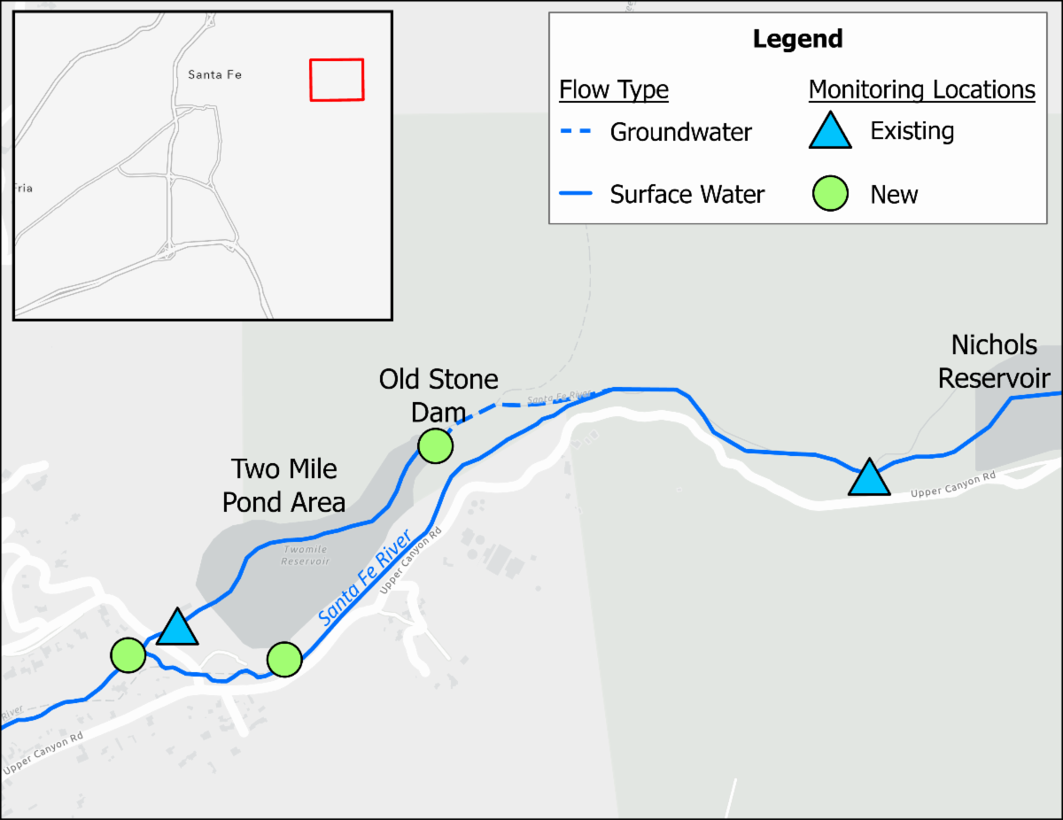 For many years, the City has been measuring water flow in the Santa Fe River between Nichols Dam and Cerro Gordo Road. To better understand the hydrology of the area and the water losses that occur when water moves through or around the Two Mile Pond area, additional monitoring station locations are being evaluated. Potential locations include a new location in the groundwater-fed channel above the Two Mile Pond area, a new location in the Santa Fe River as it flows around the Two Mile Pond area, and a new location below where the Santa Fe River joins the flows coming out of Two Mile Pond. The map shows the locations of existing and planned monitoring locations. The City hopes to be monitoring flows in the new locations by the end of the year.
What about the impact to the area around the pond?
In addition to measuring the inflow and outflow of the Two Mile Pond area, the City also seeks a better understanding of the pond ecosystem and how the landscape is evolving. To accomplish this, the City will engage in routine ecological monitoring that will document the biological, habitat, and basic water quality changes in the surrounding area over time.
It’s not just about Two Mile Pond, is it?
Changes to the flow of water and infrastructure in the area have the potential to not only affect the Upper Canyon Road area but also the Santa Fe River greenspace and ecosystem throughout the City, downstream acequia deliveries, and the City’s water supply.
Will the community be involved in the next steps of the process?
To help make informed decisions, the City is looking to foster broad community engagement on the issue, given the changed hydrology in the pond complex and the limited availability of water in the Santa Fe River. The first public meeting was held on September 19, 2023, at the Santa Fe Convention Center, and additional outreach events have been planned (see above for dates, times, and locations).
How can I find out about future outreach events?
Sign up for the City’s email distribution list here.